Sunday, November 4, 2012

Travois Trail/ Centennial Cone Park


Centennial Cone Park is located west of Golden. Take Hwy 93 north to Golden Gate Canyon Road.   Follow this windy road through the canyon to Robinson Hill Road  to get to the Northern Trailhead.  This park closes certain months for Hunting or mating season and some days are biking days (even) and hiking (odd) days.   Above is a pic of the "cone" which has the highest elevation in the park at 8679.
There are several different trails to take in the park. We chose a longer one (9 miles) and begun at Travois Trail. There is good signage at each junction. We took the Evening sun loop and hooked back up to Travois Trail.
I loved the beautiful trees on this hike. Some were twisted and barely hanging onto the cliffs. There were beautiful views of the mountains in the distance.
After  you get going you will be on a rocky outcropping overlooking clear creek canyon. If you look way down you can spot several creeks. At some points you will be climbing up or down switchbacks due to the elevation gain of 1,400 feet.
We went as far as the bridge at Elk Creek. This was a good spot for lunch and then to head back. The entire loop is about 13- 14 miles and seemed a bit long for everyone.

There were mainly evergreen trees dotted across the hills. Im sure in the spring it would look completely different.

Centennial Cone is located in the center of the loop trail. The ranger told us you can climb it if you go offtrail  from the Elk range trail.

I would rate this hike moderate to difficult because of the steep climb at the end of the hikeA shorter version would be 5.2 miles with 600 elevation gain to the rocky outcropping and back.

Saturday, October 27, 2012

Charlie's Bunion on Appalachian Trail/Smoky Mountains National Park

We chose this hike because of the high elevation and spectacular views. I also wanted to see what the Appalachian Trail was like. The weather didn't disappoint as we could see all the gorgeous fall colors at our destination.


The hike through the trees was so different from our other hike since we started at 5,000 ft elevation. We were for the most part , hiking through evergreens.


To start we drove to the center of the park to Newfound Gap Overlook at the parking lot where everyone stops for the views. There were photographers set up to capture the early morning laying fog in the mountains.


The trail starts out with a 1.5 mile steady ascent through a spruce fir forest. At the first junction at sweet heifer creek trail, a path leads right to a gorgeous view and a bench to relax with a snack.

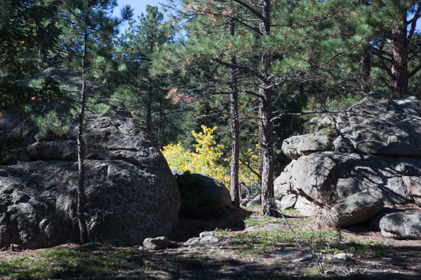
A good part of the trail consisted of hiking over tree roots.
 

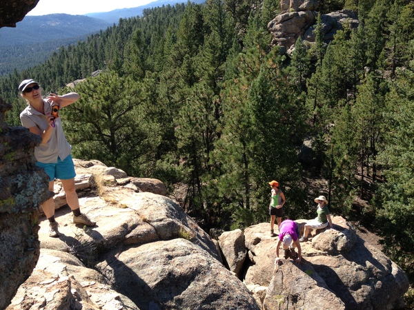
This was one of the views peeking through as we traversed the ridge.
At 2.7 miles a junction leads to Mt LeConte where you can spend the night if you have reservations. A little further a trail leads to Jump Off. This is a shorter Version at 6 miles RT versus 8.


Back on the AT in .3 miles a path to the right leads to the Icewater Spring Shelter. This is a place where backpackers on the trail can stop for the night or rest along the way. There were several notebooks that hikers have recorded some comments.


It was fun to read some of the writings in the journals by past backpackers.
Just beyond the shelter you will pass over a rusty pipe spewing onto the trail. This is Icewater Spring. Just a bit further will lead to Charlie's Bunion and the panoramic views. These are bare jagged cliffs that were created from erosion father many trees were cut down. The trail circles the knoll to head back to the trail.


This trail is 8.2 miles took us 6 hours with 1,000 elevation

These were the views from the end of Charlie's Bunion. Panoramic!!


Sunday, October 21, 2012

Rich Mountain Loop- Smoky Mountains

This hike is really a combination of several trails and starts at the entrance to Cade's Cove. This is a very popular driving tour of 11 miles that can take 2-3 hours to get around during peak months. You can get some views of Cade's cove without this drive on the Rich Mountain Loop. This hike also has tons of different trees and vegetation. I only wish I had brought along the book "Smoky Trees in the Fall" if you like to know what you're seeing.


Start this hike at the large parking lot at the entrance to Cade's Cove just behind the bicycle sign. Bynthe way, another option for this area is a bike rental when they shut down the road on Sunday and Wednesday until noon. The 11 mile road can be visited by bike to see all the historic homes and sites.


The first part of the hike begins on the Rich mountain loop trail (you will make a left at the first short junction) We went the other direction (counter clockwise) and the ascent up was much steeper.


The John Oliver cabin is quickly seen on the trail at 1.4 miles and this is an easy stretch. Cars can park and walk to this so it may be busy. The rest of the trail is quiet. We only saw 3 other groups the whole time. Also bears are seen on this trail as well. The other people we passed saw a coyote , rattlesnake, and a bear the same time we were traversing the trail.


At 3 miles you pick up the Indian Grave Gap Trail and catch a narrow-field view trail of Cade's Cove.

When you hit the junction with the Rich Mountain Trail you will be at the highest point of the mountain called Cerulean Knob about 3,500 feet. The highlight of this trail in October is the myriad of colors of the trees. The most vibrant of reds, oranges and yellows and you are hiking right through them. We didn't think the views were that spectacular, more the experience of hiking in this u usual forest- so different from Colorado. The smells and growth of humid fungi, mushrooms, lichen can be spotted along the way.


In about two miles you come to a 3 way junction with the crooked arm trail which you take on the right. This trail completes the loop. The trail descends deeply through horse ruts and tree roots. Bring your poles for this section. Enjoy the colors as you pass through. I'm not sure this trail would be as interesting without the color in the summer but maybe there would be wildflowers (not mentioned in the guidebook)

This 8.6 mile hike took us about 6 hours. 1,500 gain elevation.


Sunday, September 30, 2012

Alderfer/Three Sisters Park


Alderfer/Three Sisters Park boasts 770 acres of open space. Ever since Evergreen was settled, the four rock formations called the Three Sisters and The Brother have been landmarks providing spectacular views of the Bear Creek Basin. Over 10 miles of trail lead you around the Three Sisters and up to The Brother and connect to Evergreen Recreation District property.